

MICROBUSRTS: Create damaging winds, with little warning times and can produce winds the strength of an EF-1 tornado! So what is it and how does it form?

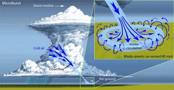
It all starts with a thunderstorm and the water droplets and hailstones being suspended high into the atmosphere within the updraft. There are many factors that can lead to evaporational cooling (sinking air) which weakens the updraft. Once this occurs, it is no longer capable of holding the large core of rain/hail up in the thunderstorm. So the core plummets to the ground all at once. As it hits the ground it spreads out in all directions. The location in which the microburst first hits the ground experiences the highest winds and greatest damage.
The image below shows just how much damage can be caused by microburst winds. This manufactured home was completely destroyed. Winds can reach up to 150mph.

Forecasting for microbursts is typically done on a near-term basis, generally within 6-12 hours before development.
Meteorologists look for converging air within the mid levels of the thunderstorm, also known as a mid-altitude radial covergence (MARC) signature. These are very hard to detect since microbursts are so short-lived and can sometimes occur between radar scans. Therefore, Severe Thunderstorm Warning lead times for microbursts can be very short, or there may be no warning at all.

When a microburst reaches the ground, a divergence signature can be seen on velocity radar. The bright red indicates winds blowing away from the radar, and the bright green indicates winds blowing toward the radar.
